Land Explorer - the story so far...
LandExplorer.coop was originally developed by one of our founding partners, Shared Assets. Kate looks back on the story of LandExplorer so far.
In 2015, Shared Assets published a snappily-titled report, “Land-Based Social Enterprise”: What is standing in the way of new models of common good land use?”, based on the experiences of the wonderful practitioners we had been working with over the previous two years. That report identified that access to information on land - or land data - was important or very important to 80% of the people we’d asked.
At the time, an increasing amount of land data was being released by the government, notably through the OpenDefra programme. However, we found that “even where data is available and free-to-access, it is often inaccessible to small organisations due to the time and expertise needed to access and analyse it.” This was compounded by the fact that “there is inequality in access to land data: Large, well-resourced organisations have the time and capacity to access good land data. This makes it hard for small socially focused organisations without similar capabilities to compete in things like identifying available land. The release of public open data is therefore often little more than a subsidy for larger organisations in the private sector, since in practice they are often the only ones able to access it.”
So we began to set our minds to thinking about how we could create a way of land-based social enterprises being able to access the data on land that they needed to help their businesses grow and thrive. In 2016, we were asked to make some proposals to the Peter Sowerby Foundation’s “community and environment” funding programme. Almost as an afterthought we added a bullet point saying “create a new land data platform for common good land users” to our list of ideas, and this was the one that piqued the foundation’s interest.
Peter Sowerby Foundation funded us (with no small thanks to the great efforts of the wonderful Tom Kenny), to initially do some more in-depth research into the data needs of common good land users. This resulted in a “Data Dive” with DataKind volunteers, the creation of a prototype platform, and the Exploring Land Data report.
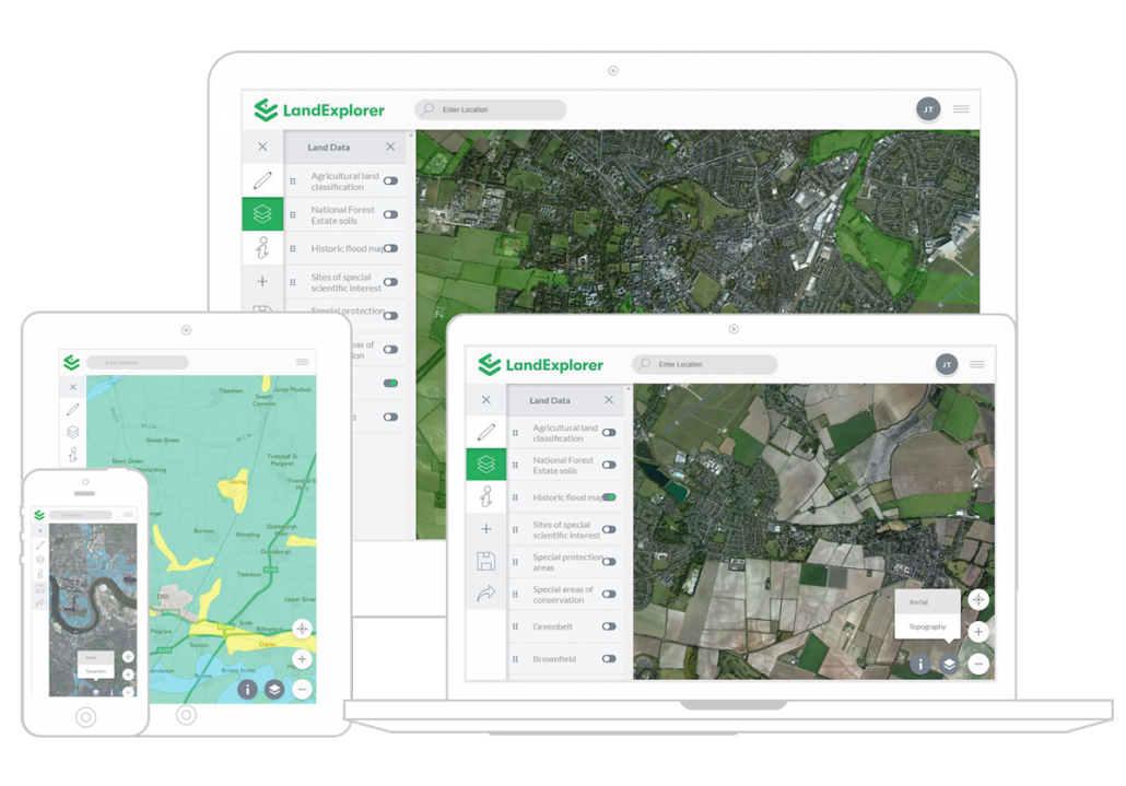
We went back to the foundation, and they gave us a second grant, in 2017, of just over £100,000 to develop the prototype into a new platform. Initially we worked with Outlandish and TableFlip who developed the first version, an Open Street Map base with a number of different open data layers, such as agricultural land classification, and historic flooding data. There were a few changes in the team (Tom moved onto pastures new, I had a baby), and we brought in Julian Thompson as a freelancer to lead on the Land Explorer (as we were now calling it) project.
Julian brought the site on hugely, in terms of its usability, working with Spork on its design and bringing in CodeOperative as developers. We integrated the Ordnance Survey base map, and new functionality, such as the ability to draw shapes on the map and measure distances and areas, as well as the ability to share the maps you had made with collaborators. Julian did a wonderful job of eeking out the Peter Sowerby grant and we attracted a good amount of users, but we always knew more funding would be needed.
Between 2017 and 2020 we unsuccessfully tried to get more funding. Developing software is expensive, and the traditional way to raise money to do it is through selling shares in a company to investors, with the aim being that you will be successful enough to sell the company and make good profits for the investors (and yourselves). We knew that we had to keep Land Explorer in the commons, and that taking private capital would put this at risk (and in any case, the people we wanted to be our customers didn’t have the kind of spending power that would make this attractive to the private market).
We realised we fell quite awkwardly between two stools. The government-supported innovation funding, like InnovateUK and Geovation, followed the logic of the private market, wanting to see commercial levels of growth in income. Charity digital funding focussed very much on the development of very local or frontline services rather than the kind of digital infrastructure we were beginning to see Land Explorer as.
Before moving on to set up Ikigai Farm, Julian had started conversations with the Solidarity Economy Association, and we realised quickly that we were facing similar issues. SEA had developed sea-map (now MykoMaps!) but were also finding it hard to understand how to fit this in with their core business model.
So, we decided to join forces and create a new organisation - Digital Commons - to see if that could act as the steward and catalyst of the kind of digital infrastructure we knew the sector and movement needed but couldn’t quite find a home for.
We set up Digital Commons in 2021, and have been deep-diving into this question. We’ve been massively helped by Lynne Davis coming on board to refine our product offering, streamlining our internal processes and really bringing creative energy and flair to the team. We have integrated commercial land ownership information and are now doing monthly releases to keep things working smoothly.
We are partners in the Resilient Green Spaces programme, creating bespoke maps to support community led food growing in Wales. We have a number of other projects up our sleeves, and see Land Explorer as a real asset for collaborative projects, as well as a useful tool for groups and individuals wanting to find out more information about the land around them.
We’d love to know how you are using Land Explorer - get in touch on hello@digitalcommons.coop to share your thoughts!